


ARGEDOR Information Technologies Ltd.

Organisation description:
ARGEDOR provides innovative information processing and visualisation solutions about the information available worldwide, with high technology products and research and development projects to companies and end users. ARGEDOR offers: Products based on geospatial information; Providing to the end user, 3D, realistic and abstract representations of the urban environment together with the capabilities easily interact with the massive information layers and analysis; Designing 3D maps scientific drawings 3D building models and data plots. (And as interactive, real time 3D graphical renderings of spatial data); Know-how in real-world data visualisation; Approaches in CityGML formats ranging from LOD0 to LOD4 objects; Data fusion, which includes all of the data point and time steps from the input data sets in real time sensor data; Big data analytics and innovative visualisation toolsets & Geospatial business intelligence toolsets.
Geospatial urban planning and visualisation is a complex and important issue in 3D city model applications, where ARGEDOR's technologies support these applications to fundamental visualise the urban environment in different scales. At this purpose for each service the use of CityGML standards what we do is a key enabling open standard for 3D smart city services. We use four levels of detail LOD1- LOD4 for thematic and spatial aspects of buildings. CityGML plays a leading role in the modularisation of urban geospatial information and 3D based techniques. ARGEDOR will provide visualisation and decision-making framework for the city design and solutions based on 3D virtual environment, innovation and integration of sensor data. The framework will support OGC standard CityGML models ranging from LOD0 to LOD4. The mentioned standard defines all of the static and dynamic entities to represent a life-like virtual city. The 3D virtual city technology also allows to visualise and realise data fusion by using real-time sensor data such as mobility data. The framework which uses state of the art video game technology will enable several high-end visualisation techniques. For example, the mobility could be visualised with transparent avatar figures illustrating the use of space and the intensity in a real-life fashion or alternatively more conceptual visualisations could be used through colouring or shape-objects in 3D city models representing the typologies of use. Numerical data will also be provided along with the visualisations. For analysing we can easily work with pilot cities including 3D city modelling for the city design and user data for designing and operating sustainable cities. ARGEDOR creates products that increase workforce efficiency, manage business processes, increase customer satisfaction and increase sales over Web. ARGEDOR works with the most talented, target oriented and continuously self-improving engineers and researchers. Our team’s extensive research projects continue with vast research and professional experience and expertise. ARGEDOR strengthens its close relationships with universities with innovative projects in where it creates innovative products in the following interest areas: Visualisation, 3D planning, Urbanisation, Smart Big Data, Data Analysis.
http://argedor.com/en
Contribution to OptEEmAL:
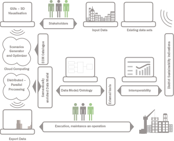
Main tasks in the project are based on deployment of the Graphical User Interfaces for the platform that is defined within the proposal. ARGEDOR provides services to allow the user to introduce the needed data within the platform, to visualise different alternatives of retrofitting scenarios (including 3D visualisation, visualisation of indicators/charts in specific fields as energy, comfort parameters, etc.) and finally to export the data generated within the platform to the user. ARGEDOR has grown to become one of the largest businesses in Geospatial Application field with providing 3D geospatial urban planning development, visualisation in Smart Cities & Communities and energy efficiency in Turkey. Expertise is to deploy interfaces to import and export data from/to the user of the platform and services for visualising and selecting design alternatives. We will work with IFC and CityGML data standards for the geometrical information of the districts to be evaluated.
Contact persons:

Güven Fidan
E-mail: guven.fidan@argedor.com
Phone: +90 312 2101340
Role in the project: Main Technical Contact

Emine Ferraro
E-mail: emine.ferraro@argedor.com
Phone: +90 312 2101340
Role in the project: Second Technical Contact